This international agreement from 1982 divides the seas into various zones, explains doctoral research fellow Gunnar Sander at the University of Tromsø.
“The right to a zone in the Arctic Ocean is restricted to the five coastal states of Norway, Russia, the USA, Canada and Greenland-Denmark.
“At the same time, other nations have rights to pursue a number of activities in the zones belonging to the coastal states. In addition come international areas which are not under any country’s jurisdiction.”
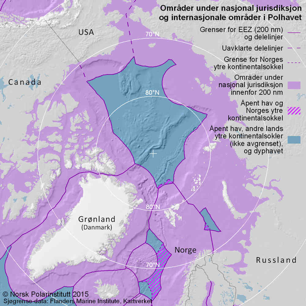
(map translation)
Zones under national jurisdiction and international areas in the Arctic Ocean
- Boundaries of EEZs (200 nm) and dividing lines
- Unclarified dividing lines
- Boundary of Norway’s extended continental shelf
- Areas under national jurisdiction within 200 nm
- High seas and Norway’s extended continental shelf
- High seas, other countries’ extended continental shelves (boundaries not shown) and the deep ocean
Greenland (Denmark) Norway Russia
© Norwegian Polar Institute 2015, Maritime boundary data: Flanders Marine Institute, Norwegian Mapping Authority
Seven zones
All seas, including the Arctic Ocean, are divided into up to seven maritime zones.
1) Internal waters
The landward side of a baseline drawn at the low-water mark or between a coastal state’s outermost islands and skerries.
2) Territorial waters
This zone extends 12 nautical miles from the baseline. It forms part of the coastal state and is the marine part of its territory. The coastal state has full sovereignty and jurisdiction.
3) Contiguous zone
The coastal state can exercise control in this zone through legislation on customs, tax, immigration and health. It extends up to 24 nautical miles from the baseline.
4) Exclusive economic zone (EEZ)
The EEZ of a coastal state extends for 200 nautical miles from the baseline (including the 12 nautical miles of territorial waters), but is not regarded as part of its territory.
However, the coastal state has sovereign rights to exploit, protect and manage the EEZ’s resources. That applies both on and beneath the seabed and in the water column, and thereby covers minerals, oil, gas and fish.
5) Continental shelf
This extends by definition at least 200 nautical miles from the baseline – in other words, to the boundary of the EEZ. Under certain conditions, however, a coastal state can also extend its continental shelf beyond that limit.
In this extended area, it has rights to the resources on and beneath the seabed but not in the water column. That means minerals, oil, gas and organisms permanently attached to the seabed, but not to fish swimming above it.
6) Seabed in the deep ocean
The seabed beyond the continental shelf is defined as humanity’s common heritage. No states have special rights, and its mineral resources must be exploited to the benefit of all people.
It is managed in accordance with these principles by the UN’s International Seabed Authority (ISA) in Jamaica.
7) High seas
This refers to the water column beyond the EEZs of the coastal states. All states have equal rights there to conduct such activities as fishing and shipping.
The extended continental shelves of coastal states must not affect activities on the high seas. A joint regime may accordingly exist in some areas, where the continental shelf and the water column are administered differently.
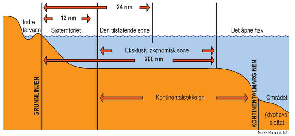
Outline of the maritime zones as defined in the UN Convention on the Law of the Sea. Illustration: Gunnar Sander and Audun Igesund, Norwegian Polar Institute.
(diagram translation)
Internal waters Territorial waters Contiguous zone Exclusive economic zone High seas
Baseline Continental shelf Continental margin Open area (abyssal plain)
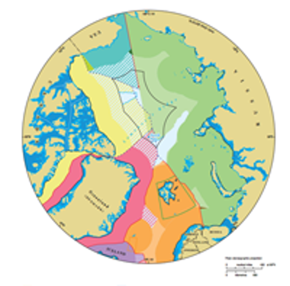
Negotiations needed
The law of the sea convention requires coastal states to negotiate with each other if their zones overlap. After its boundary treaty with Russia in the Barents Sea was signed, Norway has completed all such talks except those which might be needed over extending continental shelf areas.
The only undefined boundaries in the Arctic Ocean are those of the USA with Russia and Canada respectively. Although Canada and Greenland-Denmark have the world’s longest negotiated zone boundary, a new issue has arisen there.
This concerns Hans Island (Hans Ø), which emerged when the icecap between northern Greenland and Ellesmere Island melted. Both sides claim this territory, and are currently seeking a solution.
“The overall picture is that negotiations over Artic Ocean boundaries have been completed and few unclarified issues of sovereignty remain,” says Sander.
“But other law of the sea issues remain unresolved. These include how far the coastal state can exercise control over shipping in straits and previously ice-covered waters. Many questions relating to ocean management also need to be settled.”
Mapping
Proposals for extending continental shelf boundaries beyond 200 nautical miles must be based on seabed maps. Geology, water depth and distance from land are criteria specified in the law of the sea convention for making such claims.
Facts
The text of UN Convention on the Law of the Sea can be found here: [link til engelsk tekst]
Commission on the Limits of the Continental Shelf (CLCS)
The latter must be submitted to the UN’s Commission on the Limits of the Continental Shelf (CLCS). This comprises technical experts who review the data and analyses from the applicant, assess them in relation to the criteria in the convention, and recommend a boundary.
However, the final and binding determination of the dividing line is up to the coastal states. What would happen if one of them failed to accept the CLCS recommendation remains uncertain.
The countries with Arctic Ocean coasts have been mapping their possible continental shelf areas for many years, and Russia was the first to submit a boundary proposal to the UN in 2001.
However, the CLCS refused to take a position on this claim because it found the documentation inadequate. The Russians must therefore provide a revised application based on better data, which is expected in 2015.
Norway was the second country to come up with a proposal in 2006, and the CLCS found this by and large acceptable in 2009. However, the Norwegians have not issued a final proclamation of the boundary because of potential overlaps with other states.
Greenland-Denmark submitted its boundary proposal in December 2014, while Canada and the USA are still acquiring data as the basis for their claims.
However, the USA occupies a special position because it has not ratified the law of the sea convention and can therefore hardly submit proposals for assessment by the CLCS.
The latter can only look at continental shelf limits, and does not express any views on the division between national claims. Several boundary proposals are likely to overlap.
According to the law of the sea convention, the states concerned must then negotiate a settlement – and that process can take a long time.
While such extensions will restrict the international area, the high seas beyond the 200 nautical mile limit will always remain outside national jurisdiction,
“The countries are required to submit boundary proposals within 10 years of ratifying the law of the sea convention,” explains Sander.
“So this is not an unregulated race over territorial claims in the Arctic Ocean, but the fulfilment of an obligation and a process regulated by law.”
Resources
“Mapping of resources in the Arctic Ocean is poor,” he adds. “A number of factors – including ice cover – will make minerals, oil and gas hard to access.”
Large parts of the ocean are deep. The seabed around the Pole itself lies at depths of 4-5 000 metres.
“Even if these areas become ice-free, such deep waters are usually poor in nutrients,” observes Sander. “Fish resources in the Arctic Ocean will accordingly be largest on the continental shelves and along the marginal ice zone.
“Even if the latter moves north, it will initially remain within the EEZs of the coastal states. As long as that’s the case, fish resources will belong to the relevant country.”