All Norwegian territory in the northern hemisphere, that is, mainland Norway, Jan Mayen and Svalbard, belong to the Kingdom of Norway. In the southern hemisphere Bouvet Island is under Norwegian sovereignty. As a result of the Antarctic Treaty, Norway's sovereignty claims to Queen Maud Land and Peter I Island have been put on hold.
Territorial boundary
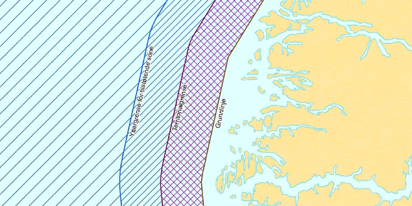
The baseline provides the basis for the calculation of Norway's territorial boundary, which is the outer boundary of Norway's sovereignty area. The territorial boundary is 12 nautical miles beyond the baseline. The boundary was increased from 4 to 12 nautical miles in 2004 for mainland Norway, Svalbard and Jan Mayen. In 2005 this was also implemented for Bouvet Island. Most coastal states have availed themselves of the right to establish territorial boundaries at 12 nautical miles.
In territorial waters Norway has full sovereignty, while foreign vessels have the right of innocent passage. Internal waters are waters within the baseline. The area from the baseline to the territorial boundary are called territorial waters.
Contiguous zone
In connection with the extension of the territorial boundary in 2004, a contiguous zone was also established outside mainland Norway out to 12 nautical miles outside the territorial boundary. Here Norway can exercise the control necessary to prevent or prosecute violations on Norwegian territory or territorial waters.
Norway's Economic Zone
The economic zone extends from the territorial boundary and out to 200 nautical miles beyond the baseline. Where there is less than 400 nautical miles to another state's baseline, the zone is delimited by the agreed demarcation lines between the states.
Norway does not have full sovereignty in this area, but rather sovereign rights over natural resources in and on the seabed and in the waters above.
Fisheries Zone
At Jan Mayen a fisheries zone has been established. The zone extends from the territorial boundary around the island and out to 200 nautical miles from the baseline. The zone does not cross the agreed demarcation line toward Greenland or Iceland. The fisheries zone is not a full economic zone, but is limited to fisheries purposes.
At Svalbard a fish protection zone has been established. This is calculated in the same manner from the baselines of the Svalbard archipelago. The zone is limited by the outer boundary of Norway's economic zone and agreed demarcation lines towards Greenland and Russia. The fish protection zone was established to preserve the living resources in the sea and to regulate fishing and hunting.
Continental Shelf
The continental shelf is the submerged prolongation of the land mass out to the great ocean depths, where the state has the right to exploit the resources in and on the seabed. In a legal sense, the Norwegian continental shelf is the seabed from the territorial boundary at 12 nautical miles from mainland Norway, Svalbard and Jan Mayen and out to the outer limits of the continental shelf or agreed demarcation line against another state.
International waters
Ocean areas that are not subject to any coastal state jurisdiction and which normally are beyond 200 nautical miles from any state's baseline, are international waters. According to UNCLOS Part VII, all states, both coastal and landlocked countries, have the right to sail ships flying their flag on the open seas.
The state must exercise control in terms of administrative, technical and social matters over ships flying its flag. International waters are reserved for peaceful purposes, and no state can claim parts of the area under its sovereignty. The Banana Hole in the Norwegian Sea and the Barents Sea Loophole are both international waters.
As a result of the demarcation line negotiations with Russia the Loophole was expanded. In the north west it was decided that the demarcation line would cut into sections of fishery protection zone around Svalbard. The area in question lies beyond 200 nautical miles from Russia, and Russia has no fishing rights in the area. Through the agreement, Norway has waived all rights on the Russian side of the demarcation line. The area in question is therefore international waters.
Datasets
Norway's maritime borders have been revised following the agreement on the Norwegian-Russian border in the Barents Sea and are collected in a vector dataset. This covers the waters of mainland Norway, Svalbard and Jan Mayen and Bouvet Island. The dataset a freely available and can be downloaded from the Norwegian Mapping Authority website.
In conjunction with the release of the dataset, concepts and terminology have been cleaned up. The once so controversial Norwegian-Russian sea border in the north has been referred to as the "dividing line", "the national border at sea" and "border to another state." None of these terms are to be used from now on. In new official maps and other official connections it will be called the “agreed demarcation line”.
The Norwegian Mapping Authority has developed concepts and terminology in the dataset in collaboration with the Ministry of Foreign Affairs and these will be used by government agencies going forward.
It is not only the dividing line that has disappeared from official vocabulary. Another term that disappears is "Norway's main land". This has been used for mainland Norway and Jan Mayen. As a collective term the "Kingdom of Norway" shall henceforth consistently be used, and this term also includes Svalbard.