The NCA's AIS chain along the Norwegian coast was established in 2005 and currently consists of 44 land-based base stations on mainland Norway and Svalbard. The base stations receive automatic and dynamic messages from vessels showing the vessel's position, course, speed and identity. All vessels over a certain size are, under international law, required to use AIS equipment when sailing.
Ships see each other
The national AIS network covers, with certain exceptions, the area from the baseline and 40-60 nautical miles out to sea. The AIS network automatically receives all AIS messages transmitted from vessels inside this coverage area. The AIS range is limited by the VHF range, which is determined primarily by the height of the antenna. The typical range from a vessel at sea is 20 nautical miles.
Vessels with AIS on board can see and follow the movements of other vessels in the area. AIS therefore serves as an anti-collision system and a supplement to radar-based information.
Static and sailing-related information is transmitted every 6th minute or when the data changes via maritime VHF communication. Dynamic information is transmitted at an update rate ranging from 3 minutes to 2 seconds, depending on the vessel's speed and course changes.
A flexible system
Automatic AIS data received by the base stations is made available to various public authorities via a web-based service. The service also displays static information about the ship's identity, type of vessel, dimensions, destination, estimated time of arrival and cargo.
The static (identity, vessel type, dimensions) and sailing related (destination, ETA, cargo, draught) information from AIS may in some cases be limited. For this reason the web-based AIS service retrieves data from other maritime information systems, so that the quality of the static and sailing-related information becomes more detailed. Combined with the SafeSeaNet Norway (SSNN) messaging system, one can for example see information on the vessel's destination, estimated time of arrival and whether the vessel is carrying a hazardous or polluting cargo. This is important information for the Norwegian Coastal Administration's traffic control centres and oil pollution preparedness. In addition, SSN information provides information on the number of persons on board, which is important information for search and rescue operations.
Under constant development
Land-based AIS has a limited range of 40-60 nautical miles, and hilly terrain and unstable weather conditions cause inadequate coverage in some areas. Further development of the service is therefore one of the NCA's focus areas, and in areas with heavy traffic the establishment of more AIS base stations is planned.
Based on today's communication requirements, users with Android phones now have the opportunity to access the NCA's AIS data by downloading a newly developed AIS app. Access to the application is search-based and user restricted.
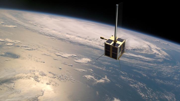
The launch of the Norwegian AISSat-1 satellite in 2010 was a quantum leap in the development of AIS as a tool in preventive maritime safety work. With AISSat-1 the NCA gained access to satellite-based AIS data that makes it possible to observe vessels in waters that currently are beyond the reach of the land-based AIS network.
With the help of AISSat-1, the maritime traffic control centre in Vardø – which is responsible for monitoring ship traffic in the Norwegian maritime zone – and the rescue coordination centres, receive AIS signals from vessels in the waters directly into their monitoring systems.
See www.kystverket.no/AIS for more information.